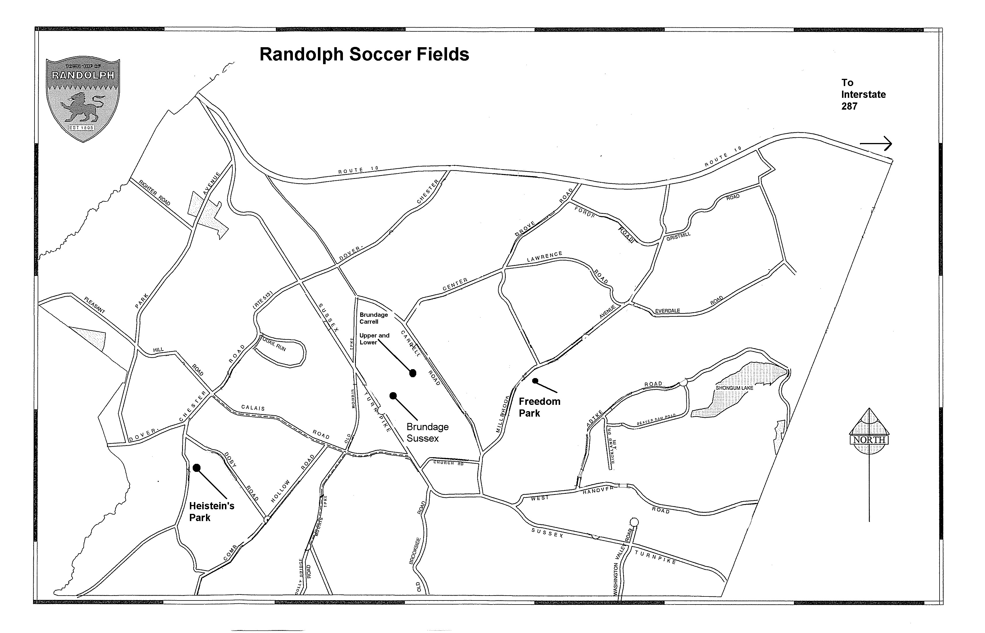
Directions to RSC Fields
HEISTEIN PARK FIELDS (HP 1-8)
South Road 07869
South Road 07869
From the South (Basking Ridge area)
Take 202 North and make a LEFT onto Tempe Wick Rd.
Go past Jockey Hollow park etc. and stay on til you reach Mendham.
Turn RIGHT onto Cold Hill Road.
-- You want the last possible RIGHT before the road ends at Main St.
-- It’s the only right that has a "right turn lane only" lane.
-- This is Cold Hill Rd but some maps call this Pitney but the sign post says Cold Hill.
Cross over 124 and stay on this road for a couple of miles.
Go down a fairly steep hill, take a LEFT at the yeild sign onto Woodland.
Go past the reservoir on your left and make your 1st LEFT onto Old Brookside.
Stay on Old Brookside til it ends at Sussex Turnpike.
Make a LEFT on to Sussex Turnpike.
Take your 2nd LEFT [a gas station is here] onto Calais Rd.
Make a LEFT at the 1st traffic light which is Dover-Chester Rd.
Go past church and make your first LEFT ("Y" in road) onto South Rd.
Entrance to the park is a couple of blocks down on the LEFT.
From the West (Long Valley area)
Take 124 through Chester.
At the light, when 24 turns to the right, continue STRAIGHT ahead on Rt 513/North Rd.
This road eventually becomes Dover-Chester Rd.
Stay on this til you make a RIGHT onto South Rd.
-- You’ll see a small green sign saying "To Hebrew Cemetery"
-- If you reach the light at Calais, you’ve gone too far.
Park is a couple of blocks down on the LEFT.
From Route 10
Route 10 to Dover-Chester Rd.
Go south (Right if you are on 10E, Left if you are on 10W) on Dover-Chester Rd.
Cross through the light at Calais
Go past church and make your first LEFT ("Y" in road) onto South Rd.
Entrance to the park is a couple of blocks down on the LEFT.
Go south (Right if you are on 10E, Left if you are on 10W) on Dover-Chester Rd.
Cross through the light at Calais
Go past church and make your first LEFT ("Y" in road) onto South Rd.
Entrance to the park is a couple of blocks down on the LEFT.
BRUNDAGE PARK - CARRELL ROAD Randolph, NJ, 07869
(BCU = Brundage carrell Upper) (BCL = Brundage Carrell Lower)
FROM THE EAST – MORRISTOWN AREA
From Speedwell Avenue in Morristown, turn onto Sussex Avenue at Shalit Drugs / firehouse / St. Margaret’s Church.
Follow Sussex Avenue approx. 5 miles uphill into Randolph, where Sussex Ave. becomes Sussex Turnpike.
Continue past West Hanover Rd., which intersects from the right.
As the road narrows and you pass a series of shops and banks, you are approaching Millbrook Avenue (traffic light).
Turn right onto Millbrook (bank on the corner) and proceed approximately ¼ mile, past Church Rd.
Make next left turn onto Carrell Rd.
Proceed 1/3 of a mile to lower field (on left side), or
Proceed another 1/3 of a mile to upper field and main parking area (on left side).
FROM ROUTE 10 (EAST, WEST)
Exit Route 10 onto Millbrook Ave. (Millbrook Ave. is the first traffic light west of K-Mart / Pathmark plaza, or east of the Randolph Diner.)
Follow Millbrook Ave. south for approx. 2.7 miles. (Along the way, you’ll pass Randolph High School and Resurrection R.C. Church.)
After passing Resurrection Church, make the first right, onto Carrell Rd.
Proceed 1/3 of a mile to lower field (on left side), or
Proceed another 1/3 of a mile to upper field and main parking area (on left side).
FROM THE SOUTH (CHESTER AREA)
Follow Route 513 (North Rd.) toward Dover.
Stay on Route 513 (North Rd.) for approx. 6 miles. North Rd. becomes Dover-Chester Rd.
--- You will pass a small strip mall in Ironia, on your right, opposite a Gulf gas station.
Continue on Dover-Chester Rd. past St. Matthew’s Church and the Ironia Fire Station.
At the traffic light just past the fire house, turn right onto Calais Rd.
Follow Calais approximately 1 mile to Morris Turnpike.
Turn left onto Morris Turnpike, and proceed approximately ½ mile to Sussex Turnpike.
Turn left onto Sussex Turnpike, then IMMEDIATELY turn right, back onto Morris Turnpike. (Randolph Recycling Center is on the right.)
Follow Morris Turnpike approx. ½ mile to Carrel Road.
Turn right onto Carrell Road. Follow Carrell Road approx. ½ mile to entrance for Brundage Park, on the right.
Turn right into the park for Upper field,
Proceed another 1/3 of a mile to lower field (on right side).
FREEDOM PARK (FP) FP-1 = Turf Field/ FP 2 = Grass field
FREEDOM PARK (FP) FP-1 = Turf Field/ FP 2 = Grass field
Millbrook Avenue, Randolph, NJ, 07869
From Route 80: Rt 80 to Route 287 South to Route 10 West.
Proceed on Route 10 West approx. 7-8 miles to Millbrook Ave Exit (Dunkin Donuts on eastbound side).
Exit and turn left - cross over Rt 10 - and proceed on Millbrook Ave past Randolph HS.
Freedom Park is apporx. 1/2 mile past High School and turn left into Freedom Park.
The Soccer pitch is in the upper right hand corner
From the West: Take I-80 east to exit 28 and follow signs for Route 10 east.
Stay on Route 10 east for 7 miles
Turn right on Millbrook Avenue for 2+- miles.
Freedom Park will be on your left just past Randolph High School.


